
Nau mai, tauti mai
Te Rūnanga o Arowhenua is the principal Māori kainga in the Aoraki region from the Rakaia to the Waitaki and back to the main divide. They are one of the 18 Paptipu Rūnanga that are leaders amongst their southern communities and are based with the marae in South Canterbury.
They primarily claim descent from the hapu Kāti Huirapa and affiliate to the iwi Waitaha, Rapuwai, Kāti Hawea, Kāti Mamoe and Ngāi Tahu. They have a responsibility for both upholding the aspirations of Kāti Huirapa while maintaining strong relationships and engagement with the wider community.
Te Runanga o Arowhenua Waiata
Available in a full PDF
KAti Huirapa -
The People of Arowhenua

Arowhenua Whānau – Meeting at the original Te Hapa o Niu Tireni, built early 1870’s
The people of Arowhenua primarily claim descent from the ancestor Huirapa. Huirapa was one of the children of Tuhaitara and Marukore from whom the majority of southern hapū descend and the tribal lineage of Waitaha, Kāti Hawea, Kāti Mamoe, and Ngāi Tahu intersect.
Kāti Huirapa are therefore a hapū or sub-tribe of the various iwi that have resided in Te Waipounamu for many generations including Kāi Tahu, Kāti Mamoe, and Waitaha, many of which traversed throughout both the North and South Islands for centuries.
The Ancient PA - Fortified Settlement, Waiateruati

Walter Mantell, Sketch Waiateruati Pā, 1848
Prior to the establishment of the settlement at Arowhenua the people maintained a strong seaside Pā site at Waiatearuati. Waiatearuati was the primary stronghold and trading post for the hapū and the most significant fortified settlement in the region. From this Pā extended many trails and paths both for gathering kai, and maintaining extended family connections across the island.
TE REHE - HE RANGATIRA
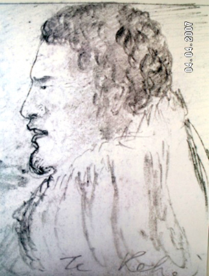
This sketch of Kāti Huirapa Rangatira, Te Rehe, was drawn by Walter Mantell - Commissioner for Extinguishing Native Claims. It is dated at Te Waiateruatī Pā on 9 October 1848. Te Rehe is acknowledged by many to be one of the leading chiefs of Kāti Huirapa in the time period.
Te Rehe and his sons regularly guided European surveyors and government agents through the South Canterbury region and hosted them at Te Waiateruatī Pā on the Ōrakipaoa River to keep abreast of the changes occurring at the time and to negotiate areas of importance in the region.
A LONGSTANDING PRESENCE IN THE AORAKI REGION

Opihi Taniwha – Hanging Rock, Opihi River circa (750-1300AD)
The ancestors of the Arowhenua people were well established across the extensive landscape between the Rakaia river to the north, Waitaki to the south, and back to the central mountain ranges of Aoraki and his brothers (Southern Alps).
Prominent Huirapa ancestors, trading trails, settlements and events extend beyond these areas to both the north and south, but the local region re ects the most concentrated signs of activity and occupation of Rapuwai, Waitaha, Kāti Hawea, Kāti Mamoe, and Kāi Tahu.
The many lakes, rivers, and corridors of native bush within the region provided rich hunting and gathering grounds for local residents, and with both uninhibited access and established rights to these resources, a long established cycle of gathering, travelling and trading was prevalent into the late 1800’s.
Some of the earliest signs of occupation in the region are the many rock art sites throughout South Canterbury. The first of these is a few kilometres west of Arowhenua, and the sites continue along valleys and waterways to inland lakes, spreading throughout the region in areas prominent for food-gathering, shelter, or semi-permanent settlement.